Eastside Transportation Study
Consultation has concluded

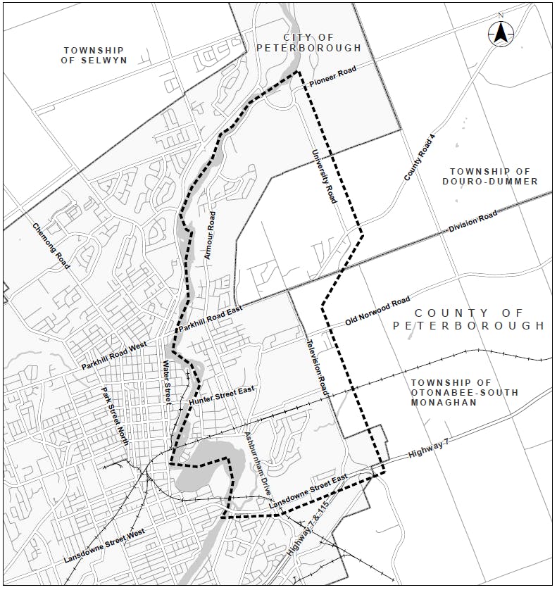
The City of Peterborough (City) has completed a Transportation Master Plan for the area east of the Otonabee River and north of Lansdowne Street East (study area). The Eastside Transportation Study (the study) assessed transportation infrastructure needs and priorities associated with development planned east of the Trent Severn Waterway and growth within the east portion of the City and provides recommendations for needed improvements to the transportation network within and beyond the study area. This study was undertaken in accordance with Approach #1 of the Master Planning Process, as outlined in Appendix 4 of the Municipal Class Environmental Assessment (MCEA) document (2023), and generally addresses Phases 1 and 2 of the MCEA process.
Recommended Transportation Improvements
The transportation improvements recommended as part of the Eastside Transportation Study include:
- Implementing the existing City-wide TMP, Cycling Master Plan and Transit Study recommendations
- Intersection modifications
- Improvements to Trent Severn Waterway and Otonabee River crossings
- Road network expansion and realignment
City Council approved these recommendations in principle on March 28, 2022. While the recommendations address the need and justification for transportation improvements at a broad level, more detailed studies will be required to complete the MCEA process for some of the projects noted in the study report.
The Eastside Transportation Study identified the realignment of Ashburnham Drive, between Maniece Avenue to Old Norwood Road/McFarlane Street, and replacement of the McFarlane Street bridge across the Trent Severn Waterway, as priority projects for the City. As such, the City is currently completing Phases 3 and 4 of the MCEA process for these projects. The first online Public Information Centre (PIC) was held in September 2022, with the second online PIC tentatively scheduled for summer 2023.
To find out more about the Ashburnham Drive Realignment and McFarlane Street Bridge Replacement MCEA, please click here.
Please use the following link to access a copy of the Eastside Transportation Study Report:
Eastside Transportation Study Report
-
June 21 to July 16, 2021 - Online Public Information Centre 1
Share June 21 to July 16, 2021 - Online Public Information Centre 1 on Facebook Share June 21 to July 16, 2021 - Online Public Information Centre 1 on X (formerly Twitter) Share June 21 to July 16, 2021 - Online Public Information Centre 1 on Linkedin Email June 21 to July 16, 2021 - Online Public Information Centre 1 linkConsultation has concludedThe Eastside Transportation Study team presented Online Public Information Centre 1 (PIC 1) from June 21 to July 16, 2021. This Online PIC provided an overview of the study background, MCEA process, existing study area conditions, problems and opportunities, preliminary evaluation criteria for assessing alternative solutions and next steps in the study process. Please use the following link to access the recorded presentation that was offered as part of this online PIC: https://estspic1.ca/

-
October 1, 2020 - Notice of Study Commencement and Public Comment Invited
Share October 1, 2020 - Notice of Study Commencement and Public Comment Invited on Facebook Share October 1, 2020 - Notice of Study Commencement and Public Comment Invited on X (formerly Twitter) Share October 1, 2020 - Notice of Study Commencement and Public Comment Invited on Linkedin Email October 1, 2020 - Notice of Study Commencement and Public Comment Invited linkConsultation has concludedThe City of Peterborough (City) is initiating a Transportation Master Plan for the area east of the Otonabee River and north of Lansdowne Street East (study area). The Eastside Transportation Study (the study) will assess transportation infrastructure needs and priorities associated with development planned east of the Trent Severn Waterway and growth within the east portion of the City and provide recommendations for needed improvements to the roadway and active transportation network within (and potentially beyond) the study area.
Study Area
Study Documentation
-
 Notice of Study Commencement and Public Comment Invited (340 KB) (pdf)
-
Notice of Online Public Information Centre 1 (384 KB) (pdf)
-
Online PIC 1 Comment Form (113 KB) (pdf)
-
Online PIC 1 Presentation Slides and Transcript (2.2 MB) (pdf)
-
Notice of Online PIC 2_Eastside Transportation Study.pdf (330 KB) (pdf)
-
Online PIC 2 Comment Form.pdf (123 KB) (pdf)
-
Online Public Information Centre 2 Transcript.pdf (167 KB) (pdf)
-
Online PIC 2 Detailed Evaluations of Alternatives 3, 4a and 4b.pdf (297 KB) (pdf)
-
Online Public Information Centre 2 Slides (806 KB) (pdf)
-
ESTS Executive Summary (1.87 MB) (pdf)
-
Eastside Transportation Study Report (12.9 MB) (pdf)
-
ESTS Appendix A (1.42 MB) (pdf)
-
ESTS Appendix B (4.4 MB) (pdf)
-
ESTS Appendix C (399 KB) (pdf)
-
ESTS Appendix D1 (760 KB) (pdf)
-
ESTS Appendix D2 (4.62 MB) (pdf)
-
ESTS Appendix D3 (131 KB) (pdf)
-
ESTS Appendix D4 (4 MB) (pdf)
-
ESTS Appendix D5 (23.1 MB) (pdf)
