Share Our Watershed, Our Blueprint on FacebookShare Our Watershed, Our Blueprint on X (formerly Twitter)Share Our Watershed, Our Blueprint on LinkedinEmail Our Watershed, Our Blueprint link
Project Vision: A healthy and resilient watershed that protects, sustains and enhances our evolving communities
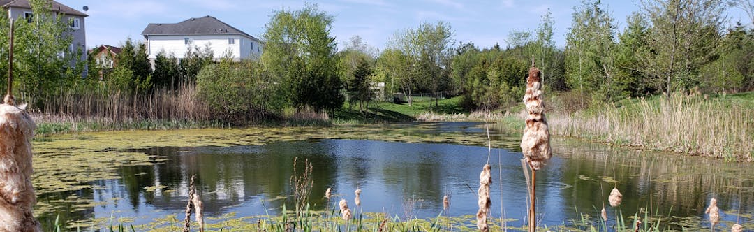
No matter where you live or work, we are all located in a watershed. A watershed is simply defined as an area of land that drains surface water into a river or stream. Protection and enhancement of a watershed and the water resource system, including surface water and groundwater features, is a priority action for the City of Peterborough. Provincial policy further requires Watershed Planning to inform municipal decisions related to growth and infrastructure.
The threats associated with climate change and land-use change can resultContinue reading
Project Vision: A healthy and resilient watershed that protects, sustains and enhances our evolving communities
No matter where you live or work, we are all located in a watershed. A watershed is simply defined as an area of land that drains surface water into a river or stream. Protection and enhancement of a watershed and the water resource system, including surface water and groundwater features, is a priority action for the City of Peterborough. Provincial policy further requires Watershed Planning to inform municipal decisions related to growth and infrastructure.
The threats associated with climate change and land-use change can result in a significant impact to watersheds in the Peterborough area. The watershed plan is intended to set a clear vision, with associated goals, objectives and targets that will help us adapt our land-use and infrastructure policy or guidance, in light of climate change.
The watershed planning process is a collaborative effort, dedicated to the protection and enhancement of our water resources. The Watershed Planning Study provides a framework for the protection and management of our water resources. The study has assessed the cumulative impacts of activities across the watershed which will ultimately help the City make decisions for growth and land use within the watershed. You can explore the Watershed Planning Study area by visiting our watershed plan mapping application.
Engagement and Collaboration
The community’s voice is an integral part of the project process. By asking for the community’s knowledge of issues, constraints and opportunities as well as ideas to shape the vision and goals, the study and eventual Plan can be tailored to address local feedback and concerns. Community feedback will also contribute to the Project Team's knowledge of local issues. The engagement plan for this project has two principle goals:
To provide key stakeholders, community organizations and the public with the opportunity to provide input and feedback to inform the Watershed Plan; and
To raise awareness regarding the development of the plan and the importance of watershed planning in general.
Further expertise and input are being obtained through a Watershed Coordinating Committee (WCC) and a Technical Working Group (TWG). The WCC is comprised of members from our neighboring Municipalities, the County, First Nations, and Otonabee Conservation. The TWG is comprised of subject matter experts who live and work in the community. These groups will meet regularly throughout the Watershed Planning process to provide input and comment on the plan.
Our Watershed, Our Blueprint has finished this stage
The Public Launch Event was held on June 19, 2019. Public consultation on a vision and concerns for the watershed occurred throughout the summer of 2019.
Phase 1a Watershed Characterization
Our Watershed, Our Blueprint has finished this stage
The City, our consultants, and partners are collecting existing data in the study area. Our team will use the existing data, and examine the results of our public consultation to date, to formulate the vision, goals, and objectives for the watershed.
Phase 1b Watershed Vision, Goals, Objectives and Targets
Our Watershed, Our Blueprint has finished this stage
Vision statement, goals and objectives will guide the focus of the Watershed Plan and future implementation and monitoring.
Phase 2 Watershed Technical Study
Our Watershed, Our Blueprint has finished this stage
Technical components of the study (e.g. modeling) will be ongoing throughout spring/summer 2021.
Phase 3 Draft Watershed Plan and Implementation Plan
Our Watershed, Our Blueprint has finished this stage
The first draft of the Watershed Plan and Implementation Plan is anticipated in Winter 2022.
Phase 3 Consultation and Survey
Our Watershed, Our Blueprint has finished this stage
In the Winter of 2022, there will be further consultation with Watershed Coordinating Commitee on the Draft Watershed Plan.
Final Watershed Plan Public Review and Presentation to Council
Our Watershed, Our Blueprint is currently at this stage
All study components are anticipated to be completed in 2025.
Watershed Plan Implementation and Monitoring
this is an upcoming stage for Our Watershed, Our Blueprint
Watershed Plan implementation and monitoring is ongoing.


 DRAFT_Characterization Report_May2020 (91 MB) (pdf)
