Park Street North Improvement Project
Share Park Street North Improvement Project on Facebook Share Park Street North Improvement Project on X (formerly Twitter) Share Park Street North Improvement Project on Linkedin Email Park Street North Improvement Project link
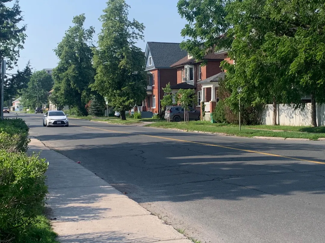
Image of Park Street looking north at Hunter Street. The image shows a leafy green residential neighbourhood and two cars.

July 2026: Consultation is currently underway for the Park Street North Improvement Project. Information about the proposed improvements is found below. Please review and provide your input through the Project Survey and/or Project Comment Form.

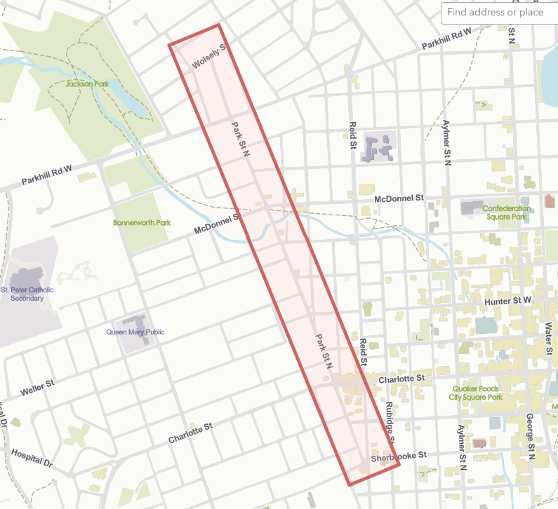
The City of Peterborough is reviewing transportation safety, cycling, and pedestrian improvements for Park Street North from Wolsely Street to Sherbrooke Street. This project supports improved mobility safety and connectivity from the north end to central area destinations in support of the goals identified in the Transportation Master Plan.


Background

Park Street is undergoing road surface repairs in 2026. As a part of this work, new asphalt and pavement markings will be applied to the roadway. These activities provide the City of Peterborough with an opportunity for cost-effective, coordinated, and proactive movement towards transportation improvements outlined in the Transportation Master Plan.

The recommended improvements serve to enhance safety and mobility for all modes of travel along a key corridor in the city’s central area. Dedicated space for people on bikes along the corridor will gently narrow lane widths and to buffer curbside pedestrian activities from moving vehicles. Vehicle flow and volumes will be maintained, while vehicle speeds will be mitigated through the design elements and speed reductions. Overall, the improved corridor will provide greater access to employment, schools, shops, and activities in the area. The current project is also a timely inclusion in 2026, as it will complement upcoming projects, including a new pedestrian crossing at Hunter Street and Park Street and reconstruction of Charlotte Street.


Study Area

The study area for this project is Park Street from Wolsely Street to Sherbrooke Street. The segment of Park Street that lies within the Study Area primarily supports low-density residential uses, and occasional convenience stores, food shops, and offices, with the greatest proportion at the intersection with Charlotte Street. There is little to no continuous retail frontage along this segment, however Park Street intersects with McDonnel Street, Charlotte Street, King Street, and Sherbrooke Street which have greater commercial amenities and as such, retail is congregated at these intersections. This proximity to key commercial corridors with a range of broader uses (e.g., schools, offices, etc.) means that many destinations are within easy walking distance of the corridor.

The adjacent land uses have a human-scale form and the presence of mature trees and informal landscaping contribute to a softening of the built environment, enhancing the attractiveness of this as a key active transportation route.

Transit and Pedestrian ConnectionsFigure 1 shows Transit Routes in the Park Street North Study AreaFigure 1: Transit Routes in the Park Street North Study Area
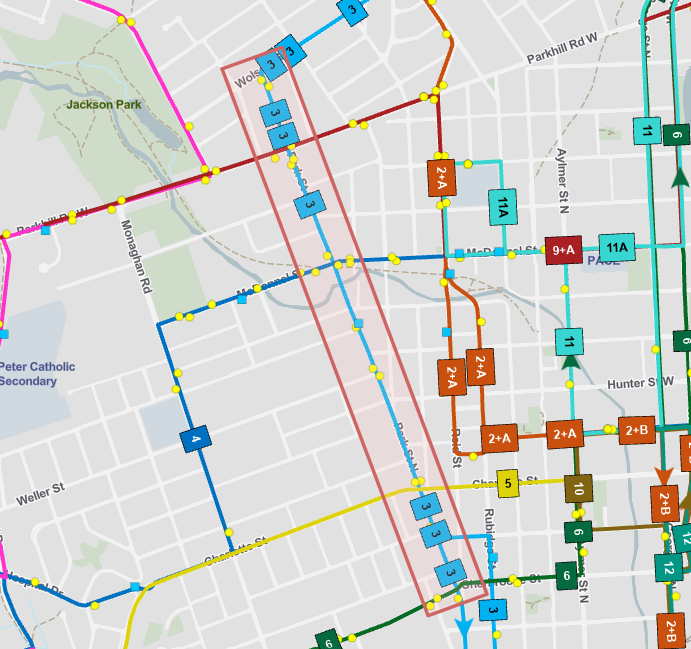
Peterborough Transit Route 3 runs north and south along Park Street with transit stops at Wolsely Street, Parkhilll Road, McDonnel Street, Hopkins Street, Weller Street, Charlotte Street, and King Street. There are transfers to Route 9 at Parkhill Road, Routes 4 and 23 at McDonnel Street, Routes 5 and 22 at Charlotte Street and Route 6 at Sherbrooke Street.

Park Street has sidewalks on both sides of the street for the majority of its length, however blocks south of McDonnel Street have curb-face sidewalk and/or missing sidewalk. Signalized crossings currently exist at Parkhill Road, McDonnel Street, Charlotte Street and Sherbrooke Street. A pedestrian crossing is planned at Park Street and Hunter Street.
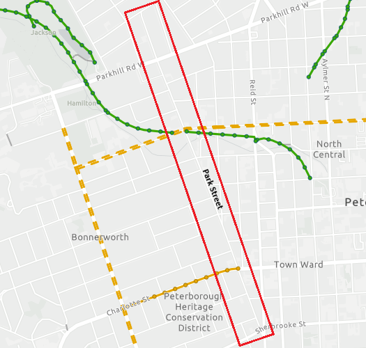

Figure 2 shows the existing cycling connections in the Park Street North Study AreaFigure 2: Cycling Connections in the Park Street North Study AreaCycling Connections

People riding bikes are observed utilizing Park Street in its current condition. The street is intersected by key crosstown route connections, including the Trans Canada Trail at McDonnel Street, and existing cycling infrastructure at McDonnel Street and Charlotte Street.

As the Ultimate Cycling Network grows, this connection will link with cycling facilities along Wolsely Street to Chemong Road and Fairbairn Street in the north providing a key connecting link from the north end into the central area.


Proposed Corridor Improvements

Park Street North from Wolsely Street to Charlotte Street
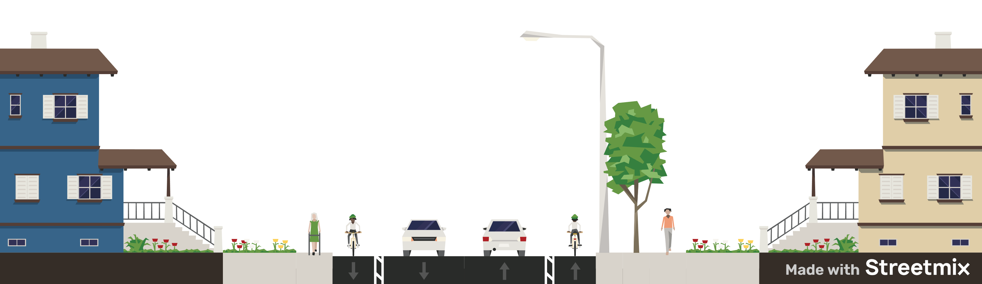

Proposed configuration of Park Street North from Wolsely Street to Charlotte Street showing residential lots, pedestrian sidewalks, buffered bike lanes and two vehicle travel lanes.Figure 3: Proposed configuration of Park Street North from Wolsely Street to Charlotte Street

Proposed Changes from Wolsely Street to Charlotte Street

  • Discourage speeding by narrowing travel lanes
  • Improve connectivity by adding buffered bike lanes
  • Enhance pedestrian comfort by providing buffer from vehicle traffic
  • Reduce posted speed limit to 40km/hr
  • Remove on-street parking and reallocate to side streets
    • Note that peak hour parking along the nine blocks is five vehicles

Park Street North from Charlotte Street to Sherbrooke Street

This section of Park Street North may receive a similar set of changes to what is outlined for the Wolsely Street to Charlotte Street section, however vehicle data analysis shows that vehicle volumes and speeds decrease south of Charlotte Street offering a second option. The second option would allow for retention of on-street parking, which does increase during the daytime hours for these two blocks (peak hour = 9 vehicles).
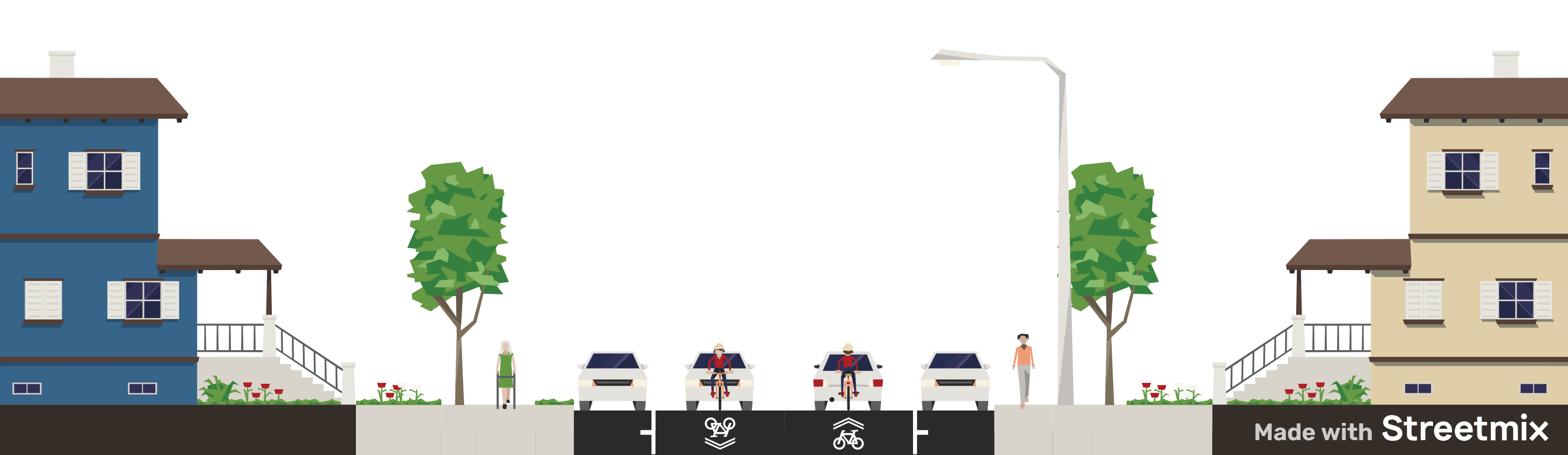

Proposed configuration of a second option from Charlotte Street to Sherbrooke Street showing residential streetscape with pedestrian sidewalks and shared space for cyclists and drivers.Figure 4: Proposed configuration of a second option from Charlotte Street to Sherbrooke Street

Proposed Changes from Wolsely Street to Charlotte Street

  • Discourage speeding by narrowing travel lanes
  • Formalize shared space with pavement markings
  • Enhance pedestrian comfort by providing buffer from vehicle traffic
  • Reduce posted speed limit to 30km/hr

Current Status of Project

The City of Peterborough is currently inviting residents to learn more and provide feedback on the proposed mobility improvements for Park Street North. Comment can be provided through the online survey and comment form found below.

Accommodations upon Request

The City recognizes some people may not be able to use various online public engagement features. Contact the Project Team for an accommodation to access engagement tools such as questionnaires and comment forms. It's important to receive feedback from people of all abilities to help shape this project. We're happy to help.


July 2026: Consultation is currently underway for the Park Street North Improvement Project. Information about the proposed improvements is found below. Please review and provide your input through the Project Survey and/or Project Comment Form.

The City of Peterborough is reviewing transportation safety, cycling, and pedestrian improvements for Park Street North from Wolsely Street to Sherbrooke Street. This project supports improved mobility safety and connectivity from the north end to central area destinations in support of the goals identified in the Transportation Master Plan.


Background

Park Street is undergoing road surface repairs in 2026. As a part of this work, new asphalt and pavement markings will be applied to the roadway. These activities provide the City of Peterborough with an opportunity for cost-effective, coordinated, and proactive movement towards transportation improvements outlined in the Transportation Master Plan.

The recommended improvements serve to enhance safety and mobility for all modes of travel along a key corridor in the city’s central area. Dedicated space for people on bikes along the corridor will gently narrow lane widths and to buffer curbside pedestrian activities from moving vehicles. Vehicle flow and volumes will be maintained, while vehicle speeds will be mitigated through the design elements and speed reductions. Overall, the improved corridor will provide greater access to employment, schools, shops, and activities in the area. The current project is also a timely inclusion in 2026, as it will complement upcoming projects, including a new pedestrian crossing at Hunter Street and Park Street and reconstruction of Charlotte Street.


Study Area

The study area for this project is Park Street from Wolsely Street to Sherbrooke Street. The segment of Park Street that lies within the Study Area primarily supports low-density residential uses, and occasional convenience stores, food shops, and offices, with the greatest proportion at the intersection with Charlotte Street. There is little to no continuous retail frontage along this segment, however Park Street intersects with McDonnel Street, Charlotte Street, King Street, and Sherbrooke Street which have greater commercial amenities and as such, retail is congregated at these intersections. This proximity to key commercial corridors with a range of broader uses (e.g., schools, offices, etc.) means that many destinations are within easy walking distance of the corridor.

The adjacent land uses have a human-scale form and the presence of mature trees and informal landscaping contribute to a softening of the built environment, enhancing the attractiveness of this as a key active transportation route.

Transit and Pedestrian ConnectionsFigure 1 shows Transit Routes in the Park Street North Study AreaFigure 1: Transit Routes in the Park Street North Study Area

Peterborough Transit Route 3 runs north and south along Park Street with transit stops at Wolsely Street, Parkhilll Road, McDonnel Street, Hopkins Street, Weller Street, Charlotte Street, and King Street. There are transfers to Route 9 at Parkhill Road, Routes 4 and 23 at McDonnel Street, Routes 5 and 22 at Charlotte Street and Route 6 at Sherbrooke Street.

Park Street has sidewalks on both sides of the street for the majority of its length, however blocks south of McDonnel Street have curb-face sidewalk and/or missing sidewalk. Signalized crossings currently exist at Parkhill Road, McDonnel Street, Charlotte Street and Sherbrooke Street. A pedestrian crossing is planned at Park Street and Hunter Street.


Figure 2 shows the existing cycling connections in the Park Street North Study AreaFigure 2: Cycling Connections in the Park Street North Study AreaCycling Connections

People riding bikes are observed utilizing Park Street in its current condition. The street is intersected by key crosstown route connections, including the Trans Canada Trail at McDonnel Street, and existing cycling infrastructure at McDonnel Street and Charlotte Street.

As the Ultimate Cycling Network grows, this connection will link with cycling facilities along Wolsely Street to Chemong Road and Fairbairn Street in the north providing a key connecting link from the north end into the central area.


Proposed Corridor Improvements

Park Street North from Wolsely Street to Charlotte Street


Proposed configuration of Park Street North from Wolsely Street to Charlotte Street showing residential lots, pedestrian sidewalks, buffered bike lanes and two vehicle travel lanes.Figure 3: Proposed configuration of Park Street North from Wolsely Street to Charlotte Street

Proposed Changes from Wolsely Street to Charlotte Street

  • Discourage speeding by narrowing travel lanes
  • Improve connectivity by adding buffered bike lanes
  • Enhance pedestrian comfort by providing buffer from vehicle traffic
  • Reduce posted speed limit to 40km/hr
  • Remove on-street parking and reallocate to side streets
    • Note that peak hour parking along the nine blocks is five vehicles

Park Street North from Charlotte Street to Sherbrooke Street

This section of Park Street North may receive a similar set of changes to what is outlined for the Wolsely Street to Charlotte Street section, however vehicle data analysis shows that vehicle volumes and speeds decrease south of Charlotte Street offering a second option. The second option would allow for retention of on-street parking, which does increase during the daytime hours for these two blocks (peak hour = 9 vehicles).


Proposed configuration of a second option from Charlotte Street to Sherbrooke Street showing residential streetscape with pedestrian sidewalks and shared space for cyclists and drivers.Figure 4: Proposed configuration of a second option from Charlotte Street to Sherbrooke Street

Proposed Changes from Wolsely Street to Charlotte Street

  • Discourage speeding by narrowing travel lanes
  • Formalize shared space with pavement markings
  • Enhance pedestrian comfort by providing buffer from vehicle traffic
  • Reduce posted speed limit to 30km/hr

Current Status of Project

The City of Peterborough is currently inviting residents to learn more and provide feedback on the proposed mobility improvements for Park Street North. Comment can be provided through the online survey and comment form found below.

Accommodations upon Request

The City recognizes some people may not be able to use various online public engagement features. Contact the Project Team for an accommodation to access engagement tools such as questionnaires and comment forms. It's important to receive feedback from people of all abilities to help shape this project. We're happy to help.


Questions/Comments

Please provide any input or ask any questions you may have for review and consideration/comment by staff.
Email
loader image
Didn't receive confirmation?
Seems like you are already registered, please provide the password. Forgot your password? Create a new one now.
Page last updated: 09 Jul 2026, 07:23 AM